RoadScope
We Are Route Intelligence
RoadScope powers the entire heavy-haul pipeline — from vehicle-mounted LiDAR capture and DJI drone imagery to permit-ready routes, weather analysis, Insta360 street view, professional maps, convoy execution, and client delivery. The platform the industry was missing.
609,000+
Bridges Indexed
165,435+
POIs Documented
16,544+
km Surveyed
99.9%
Uptime
Trusted By Industry Leaders
The Industry Evolved. The Tools Hadn't.
Heavy-haul transport has changed dramatically — loads are bigger, regulations are tighter, and the margin for error has shrunk to zero. But the tools most carriers and surveyors still use? Spreadsheets, paper maps, and generic GPS apps designed for passenger cars.
RoadScope was built from the field up — by the same teams who've been running route surveys, managing convoys, and filing permits for 15+ years. Every feature exists because someone needed it on a real job, not because it looked good in a pitch deck.
The result: a platform that connects field capture, route intelligence, client delivery, and convoy execution into one continuous workflow — eliminating the handoffs, re-entry, and data gaps that slow down every move.
Who Uses RoadScope?
Built for the professionals who move the impossible
Heavy Haul Carriers
Problem
Route failures, bridge strikes, and permit rejections cost time, money, and reputation.
Solution
Pre-trip clearance verification against load dimensions with 609,000+ bridge records and field-verified POI data.
Result
Fewer failed deliveries, defensible evidence for compliance, and faster permit approvals.
Route Surveyors
Problem
Manual survey methods are slow, inconsistent, and produce data that’s hard to share or defend.
Solution
LiDAR-based capture with MeasurePRO feeds directly into RoadScope for instant route intelligence and professional maps.
Result
10x faster survey-to-deliverable workflow with millimetre-grade accuracy and full traceability.
Permit Specialists
Problem
Permit applications require professional documentation that generic mapping tools can’t produce.
Solution
Permit-ready PDF reports with jurisdiction analysis, constraint documentation, and branded professional maps.
Result
Higher approval rates, faster turnaround, and documentation agencies trust.
Escort Operators
Problem
Convoy crews lack real-time hazard awareness and rely on paper notes or memory for critical route details.
Solution
SolTecNAV turn-by-turn guidance with low-bridge alerts, POI proximity warnings, and convoy coordination.
Result
Zero-surprise convoys with real-time hazard alerts and multi-vehicle synchronization.
The Complete Heavy-Haul Ecosystem
Five integrated steps that cover the entire heavy-haul workflow — from field survey to convoy execution. No gaps, no handoffs, no data re-entry.
SolTec Field Ops
Expert LiDAR crews deploy with vehicle-mounted hardware to survey your routes across North America.
Field Capture Suite
MeasurePRO (LiDAR clearances), SweptPRO (turning radius simulation), ProfilingPRO (Duro route profiles), LoadPRO (axle/total load analysis). DJI drone imagery auto-positioned at correct scale.
RoadScope — Route Intelligence
Transform raw field data into structured route intelligence — weather along the route, Insta360 street view, professional maps, and defensible permit documentation.
Client Portal
Share routes, reports, and permit documentation with clients through branded project portals.
SolTecNAV
Export surveyed routes to mobile devices for turn-by-turn convoy execution with hazard alerts.
Platform Capabilities
Five capability areas designed around real OS/OW workflows
Field Capture Suite
- MeasurePRO — LiDAR clearances at highway speed with DJI drone imagery
- SweptPRO — turning radius simulation on the field with DJI drone imagery
- ProfilingPRO — ultra-precise route profiles via Duro sensor
- LoadPRO — axle and total load analysis by trailer/loading/position
- AI detection of 26 object classes, 49+ voice commands (EN/FR/ES)
Route Intelligence
- 609,000+ bridge inventory with clearance data
- Weather along the route — live conditions for convoy planning
- Insta360 street view integration for virtual route review
- Multi-route comparison and optimization
- Elevation/grade analysis, constraint mapping, satellite layers
Client Delivery
- Permit-ready PDF reports with jurisdiction analysis
- Branded professional maps and overlays
- Export to PDF, KML, GeoJSON, Shapefile
- Public sharing with embed options
- Project-based collaboration with RBAC
Convoy Execution
- Turn-by-turn voice guidance in EN/FR
- Low-bridge and hazard proximity alerts
- Real-time GPS tracking and ETA
- Multi-vehicle convoy coordination
- Offline capability for remote areas
Compliance & Reporting
- Version history and audit trails
- Defensible documentation for agencies
- SOC 2 Type II compliant infrastructure
- GDPR-ready data handling
- Role-based access control
RoadScope Interface
Professional OS/OW route intelligence tools
Route Intelligence Dashboard
Multi-route mapping with terrain analysis, POI clustering, and permit-ready documentation
Elevation & Grade Analysis
GPS-based elevation profiles for identifying steep grades, traction risks, and braking zones
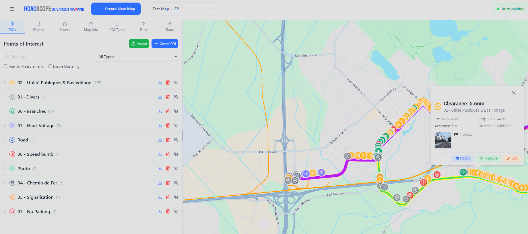
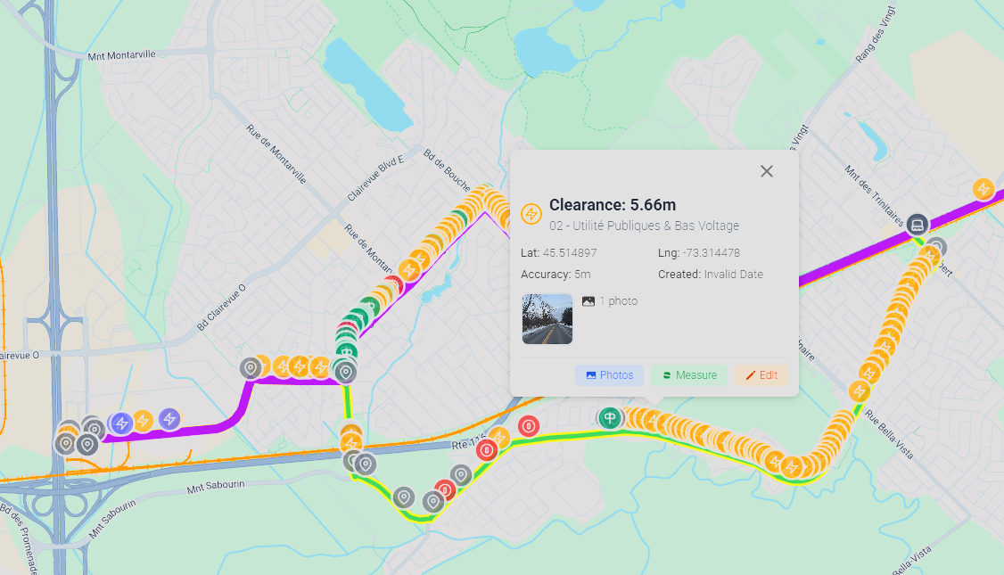
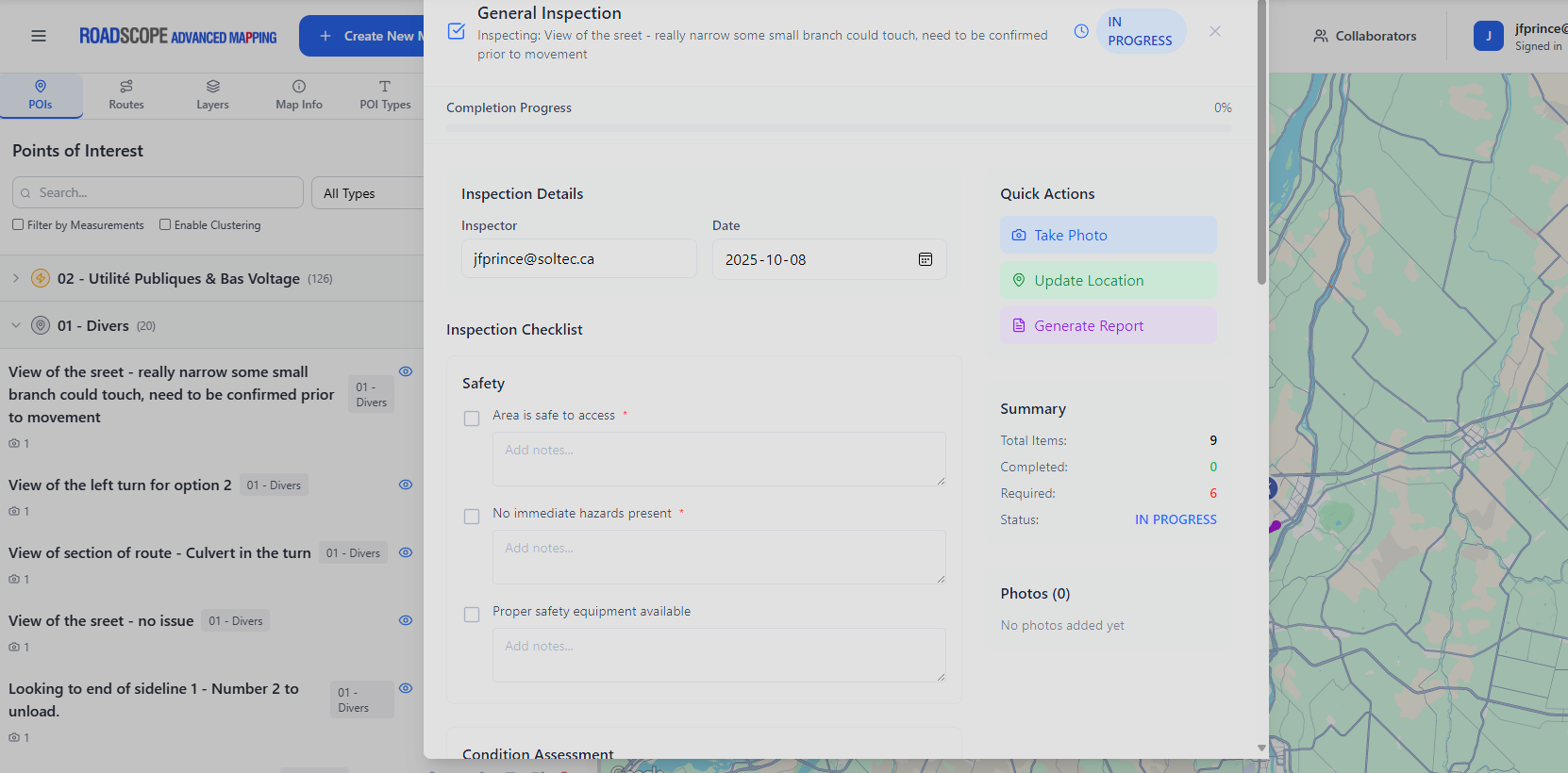
POI Inspection & Documentation
Field-verified clearances, constraints, and measurements for every point of interest
Platform Integrations & Add-ons
Extend RoadScope with specialized modules and third-party tools
MeasurePRO + SweptPRO
Vehicle-mounted LiDAR with ±2mm accuracy for clearances, plus on-field turning radius simulation. Both support instant DJI drone image import at correct position and scale.
ProfilingPRO
Ultra-precise route profiles using the Duro sensor. Capture road surface conditions, grade transitions, and elevation data for engineering-grade route documentation.
LoadPRO
Calculate axle loads and total weight for any trailer configuration, loading position, and cargo placement. Essential for permit applications and bridge crossings.
Insta360 Street View
360° street-level imagery integrated directly into RoadScope. Virtual route review, constraint documentation, and client-ready visual reports without leaving the platform.
Weather Along the Route
Live weather conditions and forecasts along your planned route. Wind speed, precipitation, visibility, and temperature data for convoy planning and safety decisions.
Camera-Bridge Windows Service
Automated bridge photo capture service for Windows. Integrates with vehicle-mounted cameras to document every bridge crossing with GPS metadata.
SolTecUSA Bridge Inventory
Access the largest OS/OW bridge inventory in North America — 609,000+ bridges with clearance data, weight limits, and structural details.
QGIS + AutoTURN
Export to QGIS for advanced spatial analysis. AutoTURN integration for swept path analysis at intersections, roundabouts, and tight geometry.
International Route Intelligence
SolTecCAN, SolTecON, SolTecDE, SolTecDOT — global infrastructure analysis and constraint mapping beyond North America.
SolTecNAV — Convoy Execution
Turn-by-turn execution for OS/OW convoys. Export surveyed routes to mobile devices for real-time navigation, hazard alerts, and multi-vehicle coordination.
Voice Guidance
EN/FR turn-by-turn
POI Alerts
Proximity hazard warnings
GPS Tracking
Real-time positioning
Convoy Sync
Multi-vehicle coordination
SolTecNAV
Turn right on County Rd 42
in 800m
LOW BRIDGE AHEAD
4.2m clearance — 1.5 km ahead
Built For Your Industry
Tailored solutions for every OS/OW operation
Heavy Haul
OS/OW carriers, fleet managers, and heavy transport operators
Wind Energy
Blade, nacelle, and tower section logistics across rural infrastructure
Engineering Consultants
Professional-grade deliverables for permit applications and route studies
Escort Providers
Pilot car operators and convoy escort teams with real-time tools
Technical Specifications
Enterprise-grade platform with professional security
Security & Compliance
- SOC 2 Type II Compliant
- GDPR Ready
- Role-based access control
- Encrypted data transmission
Platform
- Web-based — Chrome, Edge, Firefox, Safari
- Progressive Web App support
- QGIS integration
- Multi-format export (PDF, KML, GeoJSON)