MeasurePRO
Professional Measurement & Survey Application
A cutting-edge, web-based measurement and survey application with ±2mm accuracy, Insta360 360° camera, 49+ voice commands, and AI-powered detection. Built for real-time data collection, GPS tracking, and laser measurement integration.
±2mm Accuracy
IP67-rated LiDAR system
49+ Voice Commands
EN/FR/ES hands-free
AI Detection
26 object classes
Insta360 360°
Premium camera add-on
±2mm
Accuracy
0.2–250m
Range
IP67
IP Rating
30kHz
Frequency
Class 1 Eyesafe
Laser Class
RTK (Swift Duro)
GNSS
What's New in MeasurePRO
Insta360 360° Camera Integration
Full 360-degree visual documentation with real-time overlays, automatic GPS tagging, and seamless integration with measurement data. Capture complete scene context for every measurement point.
Enterprise Admin Panel
Centralized management for multi-team deployments. GPS-enforced route locking, role-based access, fleet-wide configuration, usage analytics, and compliance reporting for enterprise operations.
MeasurePro Interface
Experience the power of professional measurement software
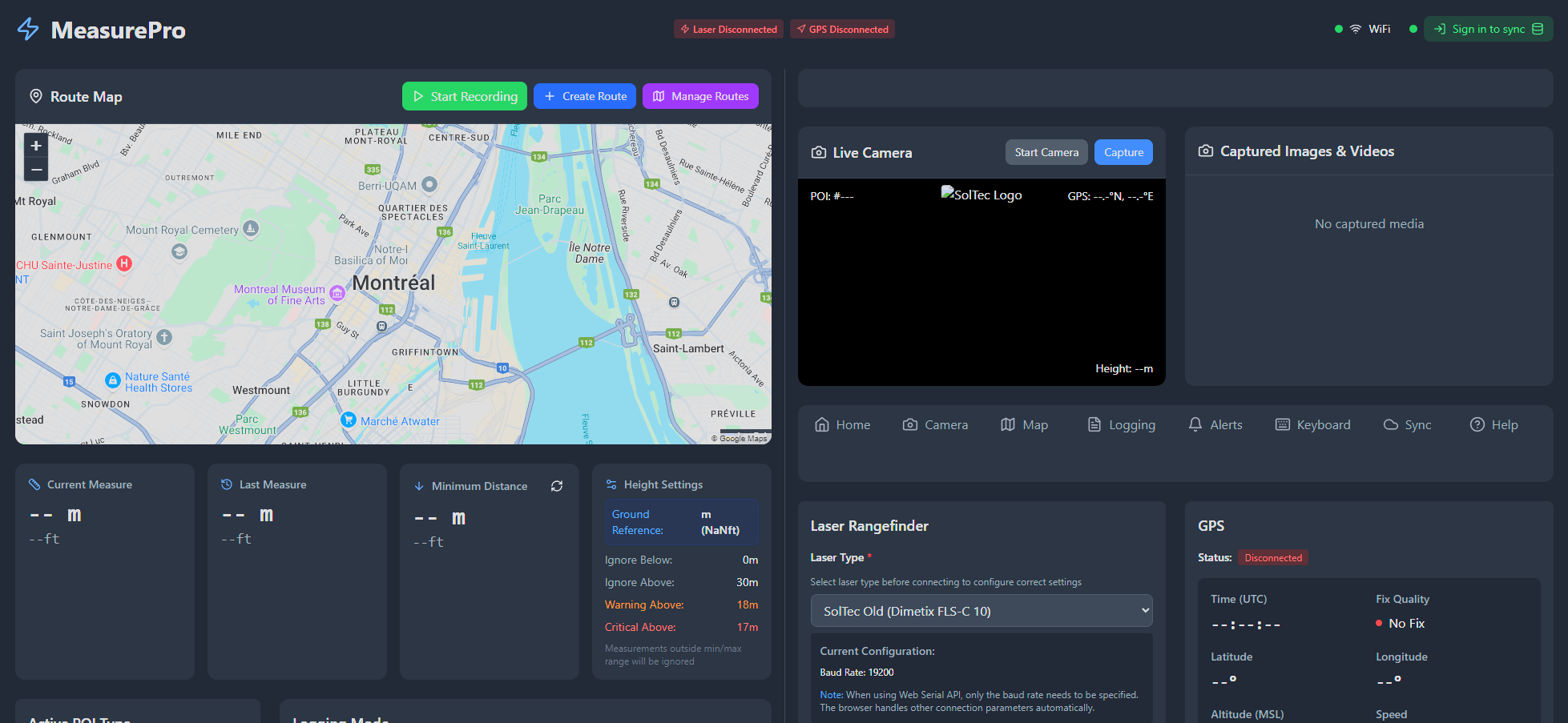
Main Measurement Dashboard
Real-time measurement display with GPS tracking and data logging
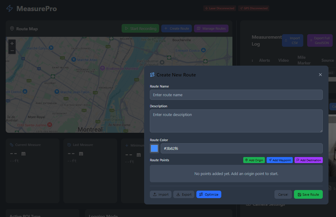
Mapping & Navigation Interface
Real-time vehicle tracking with measurement point visualization
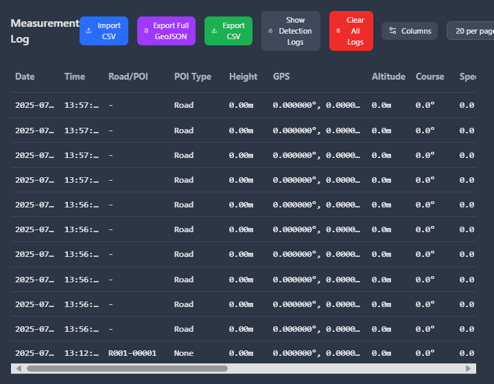
Data Export & Reporting
Export to CSV, JSON, GeoJSON, Shapefile, LandXML, and DXF for AutoCAD Civil 3D
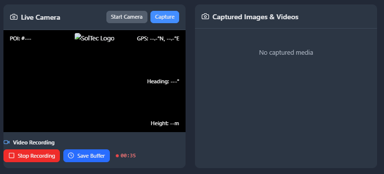
Visual Documentation System
Integrated camera capture with measurement overlays
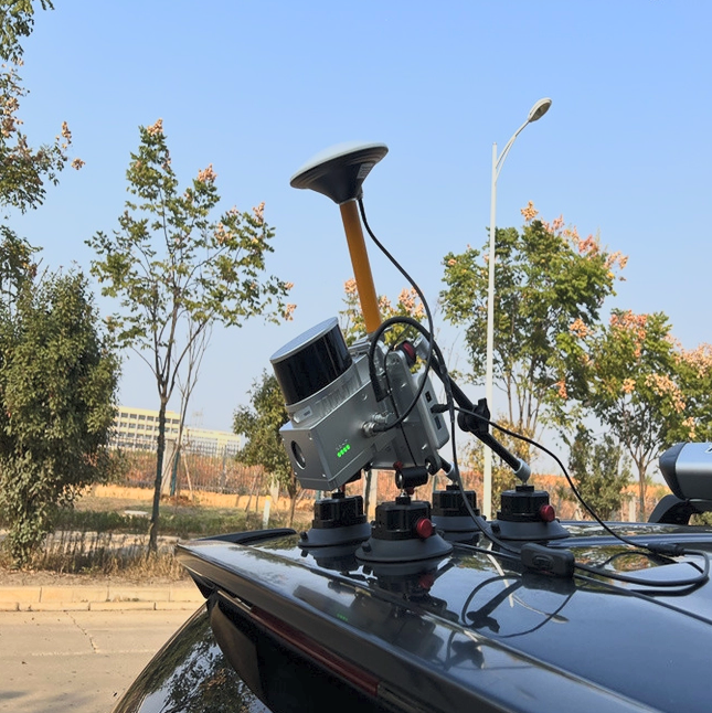
SolTec LiDAR 2D Laser System
Professional-grade laser measurement hardware designed for vehicle integration
Complete System Bundle
Everything you need to start surveying professionally
Core Features & Capabilities
Comprehensive solutions for professional measurement and surveying
Precision Measurement System
±2mm accuracy, 0.2–250m range, IP67-rated, 30kHz frequency, Class 1 eyesafe laser. RTK-GNSS (Swift Duro) centimetre-level positioning for professional surveying.
Intelligent Data Collection
Multiple logging modes including manual, automatic, and AI-powered object detection with comprehensive POI management and GPS coordinate association.
Visual Documentation System
Integrated camera capture with real-time overlays, Insta360 360° camera integration (premium add-on), automatic image logging, video recording, and comprehensive visual evidence collection.
Mapping & Navigation
Real-time map display with multiple providers, live vehicle tracking, GPS trail recording, and route planning capabilities for field operations.
Voice Commands
49+ voice commands across 3 languages (EN/FR/ES) for 100% hands-free operation
49+ Commands
Full operation control
3 Languages
English, French, Spanish
100% Hands-Free
Eyes on the road, always
Information Queries
"What is the clearance?"
Camera & Logging
"Take a photo"
AI Detection
"Start detection"
Envelope Clearance
"Check envelope"
POI Selection
"Select bridge"
Audio & Video
"Record video"
MeasurePRO+ AI Detection Suite
Powered by ZED 2i stereo camera and TensorFlow.js
AI Capabilities
- 26 object classes detected in real-time
- Automatic clearance alerts on detection
- Auto-logging when obstacles detected
- Swept path analysis integration
- Permitted route enforcement
- YOLO format export for training data
Pricing
$255/mo
LiDAR hardware from SolTec
$355/mo
Bring Your Own Device (BYOD)
Envelope Clearance Monitoring
Real-time overhead clearance with ZED 2i stereo camera
- 25 OS/OW vehicle profiles supported
- Real-time clearance alerts with audio warnings
- Visual overlay on camera feed
- Dual violation logging (photo + data)
- Color-coded clearance status display
Hardware Options
ZED 2i Stereo Camera
$1,500 — Full 3D depth sensing
Included Camera
$0 — Standard USB camera support
3-Direction LiDAR
Contact sales for pricing
Swept Path Analysis
AI road detection via OpenCV.js with real-time simulation
AI Road Detection
OpenCV.js-powered road edge and lane detection
Multi-Segment Modeling
Complex vehicle and trailer path simulation
Real-Time Simulation
Live swept path visualization on map
Collision Detection
Automatic alerts for infrastructure conflicts
Analysis History
Complete record of all analyses performed
Route Optimization
Identify best turning paths for oversize loads
Convoy Guardian Integration
Bridge-strike prevention and convoy safety from within MeasurePRO
Safety Notice: Convoy Guardian does not replace a physical high pole. It is a supplementary digital safety system that provides additional clearance monitoring and crew coordination.
Permitted Route Enforcement
GPS-enforced route compliance for OS/OW operations
GPX Route Tracking
Import and enforce permitted routes with GPS verification
Buffer Zone Visualization
Visual corridor display on live map with distance markers
Off-Route Alerts
Immediate STOP modal when vehicle deviates from permitted route
Dispatch Console
Real-time fleet monitoring with route compliance status
Specialized Measurement Modes
Purpose-built tools for infrastructure surveying
Camera Calibration Measurement
OpenCV.js camera calibration for precise bridge clearance and infrastructure surveys. Compensates for lens distortion and viewing angle to deliver accurate measurements from camera images.
Bridge Surveys
Dedicated bridge survey mode with vertical clearance profiling, structural measurement capture, and automated documentation for inspection compliance.
Lane Width & Signal Spacing
Horizontal measurement mode for lane width calculations and traffic signal spacing analysis. Critical for OS/OW route planning and permit applications.
Railroad Overhead Clearance
Specialized railroad crossing measurement with Quebec and Ontario regulatory compliance built in. Automated clearance verification against provincial standards.
Intelligent Data Collection Modes
Multiple logging modes for every surveying scenario
Manual Mode
Operator-controlled measurement logging with precise point selection
All Data Mode
Continuous automatic data capture for comprehensive surveys
Object Detection Mode
AI-powered automatic logging when obstacles are detected
Slave App Mode
Import measurements from mobile companion applications
Point of Interest (POI) Management
17 predefined POI categories plus custom support
Who Uses MeasurePRO
Purpose-built for OS/OW professionals
Pilot Car Operators & Heavy Haul Drivers
- Pre-trip clearance verification at highway speed
- Real-time overhead obstacle alerts
- Voice-command hands-free operation
- Automatic photo/video evidence collection
OS/OW Permit Planners & Engineers
- Export to Shapefile, LandXML, DXF for AutoCAD Civil 3D
- Permit-ready measurement reports
- GPS-verified clearance data for applications
- Integration with RoadScope route intelligence
Bridge & Infrastructure Inspection Teams
- Camera calibration measurement with OpenCV.js
- Bridge survey specialized mode
- Railroad overhead clearance (Quebec/Ontario compliance)
- Lane width and traffic signal spacing calculations
Transport Logistics & Safety Officers
- Blackbox-grade forensic logging
- Convoy Guardian integration for real-time safety
- Permitted route enforcement with GPS locking
- Multi-stakeholder QR code report access
Supported Professional Equipment
Compatible with industry-standard measurement devices
Laser Rangefinders
- SolTec Old (Dimetrix FLS-C 10) - 19,200 baud
- SolTec New (Acuity AR2700) - 115,200 baud
- High Pole (Jenoptik LDS-30) - 115,200 baud
GPS Modules
- Any NMEA 0183 compatible device
- RTK-GNSS (Swift Duro) — cm-level accuracy
- Support for 4800-921600 baud rates
- Browser geolocation fallback
Cameras
- Insta360 360° Camera (premium add-on)
- ZED 2i Stereo Camera (AI detection)
- USB cameras with web browser support
- Multiple resolution support (640x480 to 4K)
Key Benefits & Value Proposition
Measurable results that transform your surveying operations
Automated measurement logging and instant data export
Professional laser integration with RTK-GNSS validation
Full functionality without internet connection
Complete system bundle with 6-month license included
Technical Specifications
Modern web technologies for professional performance
Browser Compatibility
- Chrome 89+ (Recommended)
- Edge 89+
- Firefox 87+ (Limited serial support)
- Safari 14+ (Limited serial support)
Technology Stack
- React 18 with TypeScript
- Tailwind CSS responsive design
- Web Serial API for device communication
- IndexedDB for offline storage
Export Formats
- CSV for spreadsheet analysis
- JSON for data processing
- GeoJSON for GIS integration
- Shapefile for ArcGIS/QGIS
- LandXML for civil engineering
- DXF for AutoCAD Civil 3D